


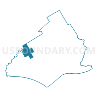
THORNBURY TWP DIST EASTERN, Delaware County, Pennsylvania
About
Outline

Summary
| Unique Area Identifier | 659344 |
| Name | THORNBURY TWP DIST EASTERN |
| County | Delaware County |
| State | Pennsylvania |
| Area (square miles) | 5.40 |
| Land Area (square miles) | 5.38 |
| Water Area (square miles) | 0.02 |
| % of Land Area | 99.69 |
| % of Water Area | 0.31 |
| Latitude of the Internal Point | 39.92114400 |
| Longtitude of the Internal Point | -75.50825840 |
Maps

Graphs
Select a template below for downloading or customizing gragh for THORNBURY TWP DIST EASTERN, Delaware County, Pennsylvania


Neighbors
Neighoring Voting District (by Name) Neighboring Voting District on the Map
- CHESTER HEIGHTS Voting District, Delaware County, PA
- CONCORD TWP PCT NORTHERN, Delaware County, PA
- EDGEMONT TWP Voting District, Delaware County, PA
- MIDDLETOWN TWP DIST 04 PCT 02, Delaware County, PA
- THORNBURY TWP DIST WESTERN, Delaware County, PA
- THORNBURY TWP VTD 02, Chester County, PA
- WESTTOWN TWP PCT 04, Chester County, PA
Top 10 Neighboring County Subdivision (by Population) Neighboring County Subdivision on the Map
- Concord township, Delaware County, PA (17,231)
- Middletown township, Delaware County, PA (15,807)
- Westtown township, Chester County, PA (10,827)
- Thornbury township, Delaware County, PA (8,028)
- Edgmont township, Delaware County, PA (3,987)
- Thornbury township, Chester County, PA (3,017)
- Chester Heights borough, Delaware County, PA (2,531)
Top 10 Neighboring Place (by Population) Neighboring Place on the Map
Top 10 Neighboring Unified School District (by Population) Neighboring Unified School District on the Map
- West Chester Area School District, PA (108,433)
- Rose Tree Media School District, PA (35,263)
- Garnet Valley School District, PA (28,553)
Top 10 Neighboring State Legislative District Lower Chamber (by Population) Neighboring State Legislative District Lower Chamber on the Map
Top 10 Neighboring State Legislative District Upper Chamber (by Population) Neighboring State Legislative District Upper Chamber on the Map
Top 10 Neighboring 111th Congressional District (by Population) Neighboring 111th Congressional District on the Map
Top 10 Neighboring Census Tract (by Population) Neighboring Census Tract on the Map
- Census Tract 4103.01, Delaware County, PA (8,284)
- Census Tract 4101, Delaware County, PA (8,028)
- Census Tract 4072.01, Delaware County, PA (5,135)
- Census Tract 3029.01, Chester County, PA (5,036)
- Census Tract 4100, Delaware County, PA (3,987)
- Census Tract 3030, Chester County, PA (3,017)
- Census Tract 4070, Delaware County, PA (2,531)